


Sydney to Brisbane Map
A city to city map designed for the journey from Sydney to Brisbane via the Pacific and New England Highways (1:1,900,000), with tourist information on towns and regions within the trip on the opposite side.
Key Features
- City maps
- 24-hour fuel
- Camping areas
- Distance grids
- Tourist attractions
- Roadside rest areas
Key Specifications
Edition: 9th
Publication Date: 01/06/16
Scale: 1:1,900,000
Folded size (WxHxD): 140mm x 250mm x 3mm
Flat size (WxH): 700mm x 1000mm
Weight: 0.08kgs
You may also like...


Savannah Way - Cairns to Broome Map
- Regular Price
- $14.95
- Sale Price
- $14.95
- Regular Price
-
- Unit Price
- Translation missing: en.general.accessibility.unit_price_separator

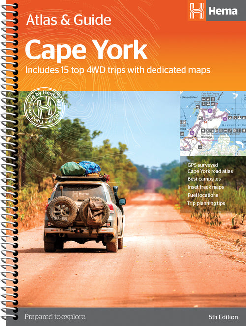

Cape York Atlas & Guide
- Regular Price
- $49.95
- Sale Price
- $49.95
- Regular Price
-
- Unit Price
- Translation missing: en.general.accessibility.unit_price_separator


Queensland State Map
- Regular Price
- $14.95
- Sale Price
- $14.95
- Regular Price
-
- Unit Price
- Translation missing: en.general.accessibility.unit_price_separator


South East Queensland Map
- Regular Price
- $14.95
- Sale Price
- $14.95
- Regular Price
-
- Unit Price
- Translation missing: en.general.accessibility.unit_price_separator


Central Queensland Map
- Regular Price
- $14.95
- Sale Price
- $14.95
- Regular Price
-
- Unit Price
- Translation missing: en.general.accessibility.unit_price_separator
Related Articles


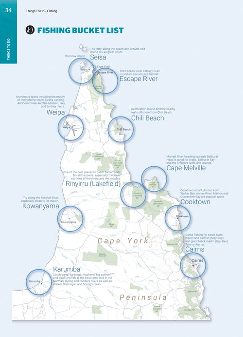
When is the best time to travel to Cape York, Qld
The Peninsula’s climate is characterised by two distinct seasons - wet and dry -...

Exploring Old Telegraph Track North, Cape York, Qld
The northern section of the Old Telegraph Track, which runs from Bamaga Road to...

Top 5 Australian Great Desert tracks
Hema Maps celebrates the release of its 6th Edition of its bestselling Great Desert...