
:
Top Five Red Centre Camping Spots
The Red Centre is packed full of excellent camper destinations and here are a few that will get your juices flowing.
Remote camping, orange sand, dry riverbeds, serenity, history and culture. This is what camping in this part of Australia is all about. A camera is a must, as is a sense of adventure as the destinations below allow you to discover some amazing places. If you haven’t been to any of these places before, chuck ‘em on your bucket list and start planning a Red Centre expedition.
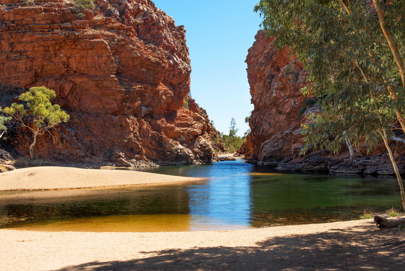
Palm Valley
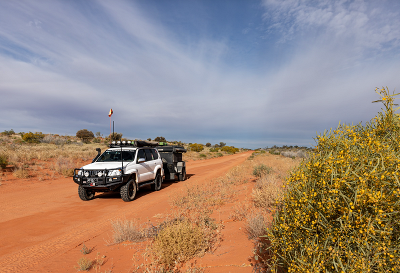
Access to the Palm Valley campground is only suitable for high clearance 4WD vehicles. Drop some air from your tyres and only tow an offroad camper or caravan, as the Finke River sand is often deep in places.
The track from the campground to Palm Valley has been modified in recent years, making it less gnarly, but high clearance will help you over the rocks that litter the track. From the car park, there are two walking options, both offering great views of the ancient Red Cabbage Palms and the valley. The palms are only found in this section of central Australia.
The 5km Mpulungkinya loop walk climbs high up onto the sandstone plateau above the palms and leads to views across Palm Paddock before dropping down deeper into the valley. The Arankala walk is a shorter 2km walk along the valley floor and amongst the palms before a shorter climb up onto the plateau and then loops back to the car park.
Not far from the campground is the Kalarranga Lookout, a short climb that offers extraordinary panoramas of the remarkable weathered sandstone hills. I can recommend the 5km loop Mpaara Walk that envelops you into the Aboriginal Dreamtime by following the story of Mpaara, the Tawny Frogmouth-man and the Pangkalanga Devil Man.
DESTINATION DETAILS
REGION: Finke Gorge National Park
NEAREST TOWN: Alice Springs is 138km east via Larapinta Drive.
WHEN TO GO: The cooler months from April to September are the best times, but the roads may close after heavy rain.
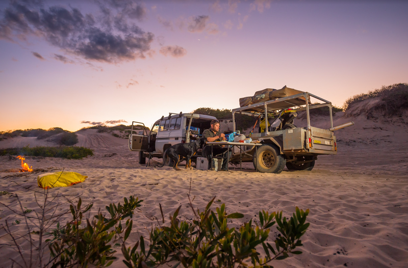
CAMPING: Camping costs $10 per adult and $5 per child, or $25 for families. Cash payments only with fees paid at the campground’s honesty box. There are flushing toilets, solar-heated showers, LPG barbecues and burners and communal fire pits. During peak times, rangers hold informative talks around the campfire.
WHAT TO TAKE: A compressor and tyre gauge, firewood, food and water. Take out what you take in.
DIFFICULTY: The 16km track into Palm Valley and campground can be accessed by high clearance 4WD. Carry extra food and water, vehicle equipment, recovery, and safety gear.
CONTACTS: NT Parks and Wildlife
Owen Springs Reserve
Once a thriving cattle station covering 1570km², Owen Springs opened as a reserve in 2003 and has become popular with overlanders searching for a great place to camp, away from the hordes. Besides the incredible bush camping, the reserve has a historic back story, as well as reminders of its pastoral heritage, best experienced on the 50km Owen Springs Self-Drive.
While the track can be driven in either direction, I’ve written this as travelling from north to south. The Homestead, now ranger station is the first set of structures you’ll come across, with the old Aboriginal quarters nearby. You can explore the quarters, although most of the “buildings” have disappeared. The Aboriginal stockmen were extremely important to the property as they were often skilled horsemen and fencers.
Crossing open plains as you close in on the Waterhouse Range, an old set of redgum yards and branding yard can be found on your left. A little further on is the Old Homestead site. William Gilbert built two log cabins in late 1873, the first homestead to be built in Central Australia. The stone homestead was built from 1886 with the operations gradually moved to the north, to Milner’s Well in the 1950s.
As you enter Lawrence Gorge, it’s easy to spot the signposts signalling where camping is permitted. The next stop is the old Haunted Tree bore, where the cattle would often be spooked when the limbs of nearby gums rubbed in the wind. The tank was washed away by a recent flood and can be found a short way downstream as you continue the drive.
Once out of the gorge, enjoy the views across the desert plains with burnt orange sand, golden grasses and mulgas. Crossing the Hugh River, the track to Redbank Waterhole soon appears on your right. There are several areas suitable for bush camping on both sides of the river with the waterhole often dry if the river hasn’t flowed for some time.
DESTINATION DETAILS
REGION: Owen Springs Reserve
NEAREST TOWN: Alice Springs is 66km north via the Stuart Highway or 50km west via Larapinta Drive.
WHEN TO GO: The cooler months from April to September are the best times, but the roads may close after heavy rain.
CAMPING: There are two remote bush camps, one between the signposts within Lawrence Gorge and at Redbank Waterhole. Most campsites require high clearance 4WD to reach them. You need to be self-reliant as there are no facilities.
WHAT TO TAKE: A compressor and tyre gauge, firewood, food and water. Take out what you take in.
DIFFICULTY: A high clearance 4WD is essential with some sections of the 50km self-drive track following or crossing the sandy riverbed of the Hugh River. Carry extra food and water, vehicle equipment, recovery, and safety gear.
CONTACTS: NT Parks and Wildlife
Henbury Meteorite Craters
It’s hard to imagine what the Arrernte people thought when a large meteorite travelling at over 40,000 kilometres per hour broke up before hurtling into the surface of the earth around 4000 years ago. The noise would have been deafening and the shock waves that ran through the earth would have startled the native animals, as well as the local inhabitants. No wonder it’s a sacred site.
Access to the Henbury Meteorite Conservation Reserve is via the unsealed Ernest Giles Road that runs between the Stuart Highway and Luritja Road, with the turnoff 15km from the highway. It is then 5km to the campground on a very corrugated road.
These days the conservation reserve is a protected area, with over 12 craters and an area that still contains meteorite fragments. Visitors are free to explore the crater field, using the walking track that leaves from the campground, and please, leave only footprints and take only photographs as the fragments you see lying all about the ground are protected.
The geological structure of the craters has helped in interpreting features on planets such as Mars, and US astronauts visited the area to prepare for moon landings. Over the years, erosion has started to wash soil into the craters, however the Aboriginal people wouldn’t drink rainwater that collected, fearing they’d be filled with iron.
DESTINATION DETAILS
REGION: Henbury Meteorites Conservation Reserve
NEAREST TOWN: Alice Springs is 145km northeast via the Stuart Highway.
WHEN TO GO: The cooler months from April to September are the best times, but the roads may close after heavy rain.
CAMPING: Remote bush camping with a small number of designated sites. Costs $4 per adult per night and $2 per child and $10 for families. Cash payments only with fees paid at the campground’s honesty box. There are pit toilets, fire pits and shelters with tables.
WHAT TO TAKE: Firewood, food and water. Take out what you take in.
DIFFICULTY: Ernest Giles Road is an unsealed and dry weather only road. The track into Henbury Craters and campground can be accessed by 2WD vehicles. Carry and drink plenty of water and slip, slop, slap.
CONTACTS: NT Parks and Wildlife
Chambers Pillar
Explorer John McDouall Stuart arrived at this stunning landmark on 6 April 1860 naming it Chambers Pillar after a mate. Stuart didn’t leave his tag on the rock, but those that followed did. William and Mary Hayes took up land at Deep Well, Warne and Randle worked on the Overland Telegraph, storekeepers, coppers, scientists have all carved their names in the rock. Thankfully it is now illegal.
Getting to Chambers Pillar is a little easier on vehicles and drivers these days, with money having been spent improving the road. Following the South Road out of Alice Springs, you’ll notice another track running beside you, this is for the annual Finke Desert Race. Take the turnoff to Maryvale Station, and don’t forget to spend some cash in the store to help a small business out.
The walking track to the Pillar leaves from the campground. Climbing the sandstone steps up to the base of the pillar provides 360 degrees views of the surrounding landscape and a walkway has been erected to allow easy viewing of the rock and to protect the fragile sandstone from erosion.
The site is significant to the local Aboriginals who retell the Dreamtime story of Itirkawara, the Gecko ancestor. A giant of a man with a violent temper, he killed several of his ancestors with his stone knife. Confident in his abilities he took a wife from the wrong tribe, enraging his relatives.
Banished, the couple returned to the desert, Itirkawara fuming and his wife shrinking in shame. They rested in the dunes and turned into rocky formations, Itirkawara into the Pillar, and his wife into Castle Rock. Sunrise and sunset are by far the best times to photograph Chambers Pillar.
DESTINATION DETAILS
REGION: Chambers Pillar Historical Reserve
NEAREST TOWN: Alice Springs is 160km north via the Old South Road. Maryvale has a store with limited supplies.
WHEN TO GO: The cooler months from April to September are the best times, but the roads may close after heavy rain.
CAMPING: Two designated campgrounds with free gas barbecues, fire pits and pit toilets. The campsites are dispersed and for $4 per night for adults, $2 per child and $10 per family, it’s great value for the money. Cash payments only with fees paid at the campground’s honesty box.
WHAT TO TAKE: A compressor and tyre gauge, firewood, food and water. Take out what you take in.
DIFFICULTY: The 45km track from Maryvale into Chambers Pillar can be accessed by 4WD vehicles and off-road campers and vans. Carry extra food and water, vehicle equipment, recovery and safety gear as the roads may be closed after rain.
CONTACTS: NT Parks and Wildlife
Rainbow Valley
As a landscape photographer, I’ve been wanting to visit the colourful sandstone bluffs and cliffs at Rainbow Valley for many years. The road into the conservation reserve is compacted sand, with corrugated sections along the way and although signposted as 4WD Only, I came across plenty of 2WD vehicles having a crack.
Closing in on the reserve, I started seeing the first glimpses of the geological formations and all I could think was, WOW! The best times to view Rainbow Valley are in the soft morning light or golden hour around sunset. As it was mid-afternoon, I decided to find a campsite and set up before heading to the day area with my camera and tripod.
Rainbow Valley is also important to the Upper Southern Arrernte people, who still use it as a place to camp and teach the kids about the place and looking after country. They call this place Wurre.
Boardwalks lead to the salt pan that lies before the main section of Rainbow Valley and you are asked to always stick to the walking trail. There are plenty of spots to wait for the right shot, and as the sun began to set below the dunes over my shoulder, the sandstone bands began to change colour from ochre red to orange and purple that matched perfectly with the explosions of colours in the skies above. I highly recommend checking this place out.
DESTINATION DETAILS
REGION: Rainbow Valley Conservation Reserve
NEAREST TOWN: Alice Springs is 75km north along the Stuart Highway. The conservation reserve is a further 22km on an unsealed road.
WHEN TO GO: The cooler months from April to September are the best times, but the roads may close after heavy rain.
CAMPING: Remote bush camping with a small number of designated sites. Costs $4 per adult per night and $2 per child and $10 for families. Cash payments only with fees paid at the campground’s honesty box. There are pit toilets, fire pits and shelters with tables.
WHAT TO TAKE: Firewood, food and water. Take out what you take in.
DIFFICULTY: The access road to the reserve is recommended 4WD only and is a dry weather track. Carry and drink plenty of water and slip, slop, slap.
CONTACTS: NT Parks and Wildlife
2 comments


Great article, just one comment: all Northern Territory NP campsites are now only bookable online, all honesty boxes have been removed or made redundant. You must book a camp site online before you arrive and remember there will be no mobile reception at most campsites.
Kind regards, Neil
According to the NT Parks website you must now book on line for Rainbow Valley. Not sure if this is the case.