
:
Hema Maps New Product: 3001 Things to See and Do in Australia
The first edition of 3001 things to see and do around Australia compiled by local explorer James Allen, is now available on the Hema Maps website and at leading retail stores.
Published by Hema Maps and including Hema locator maps, 3001 things is the ultimate travel guide – one 376-page book for a ‘big lap’ style tour which is also designed to use to discover many things in local areas.
James came up with the idea for 3001 things while on a 110,000km trip around Australia mapping indigenous song lines.
As he travelled around Australia, he realised two things:
1. Many of the places he would only visit once in his lifetime, so he didn’t want to miss out on the best beach, view, drive or hike because he didn’t know that it was there
2. With a simple, easy-to-follow map with dots, he could get more people out to see these incredible places and hopefully raise awareness of the importance of protecting them for future generations.

“There are thousands of activities to see and do and there are equally thousands more that I have left out,” James said. “I hope by using the book travellers will be able to spend more time doing and seeing and less time researching.
“My main aim of this book is to help you spend less time planning and more time doing as you travel around Australia.”
3001 things to see and do around Australia includes attractions by state, territory and region for easy navigation including must see-sites, adventures and family fun as well as history, culture and exploration.
This book makes it easy to plan your activities and routes, thanks to the use of activity icons combined with Hema’s award-winning cartography.
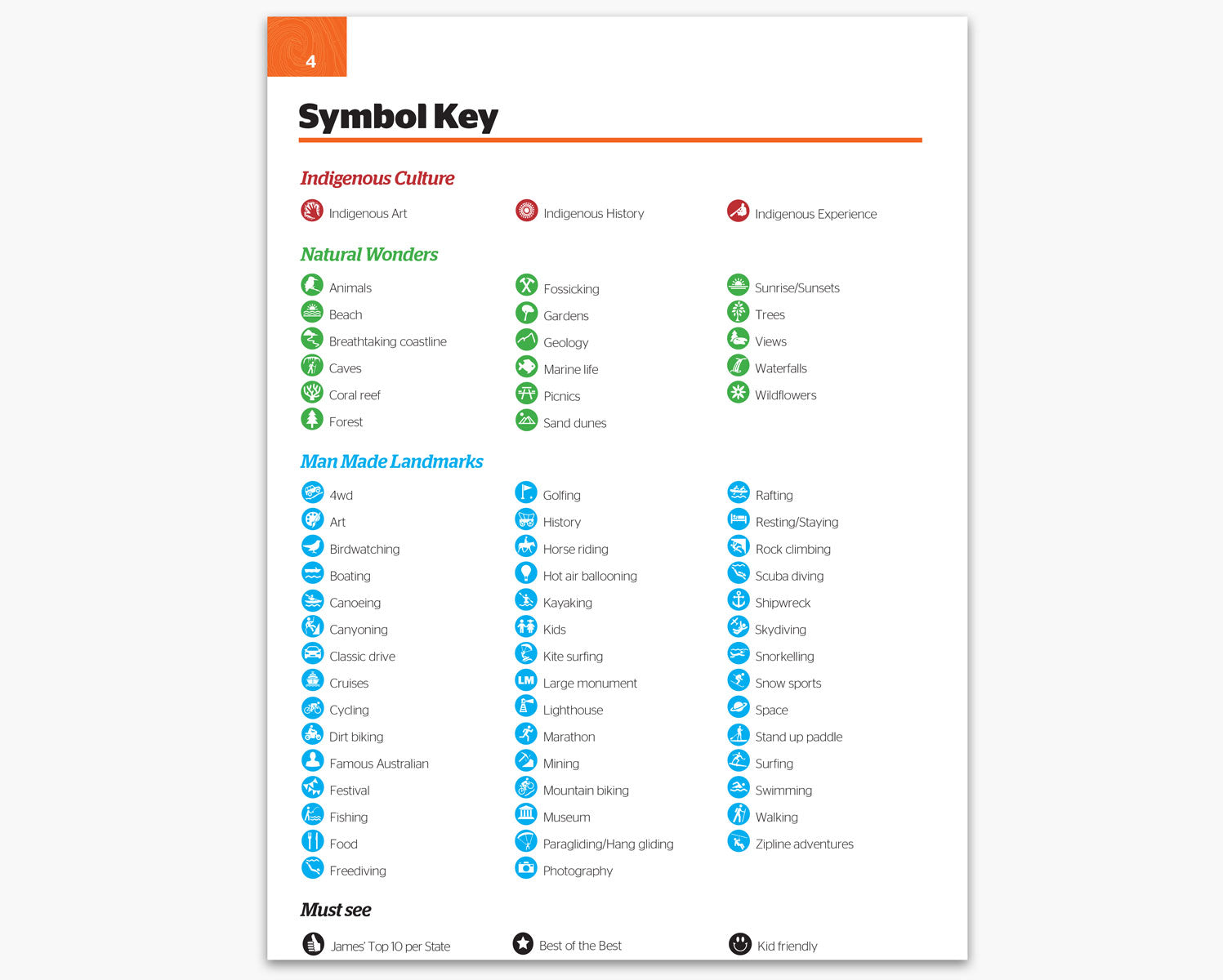
For each state and territory, Hema Maps provided an atlas section to help readers visualise where the points of interest are located. Accompanying this is an index section; the first column represents each point of interest specific to that state, listed chronologically and in alphabetical order. Readers can then find the rating (James’ Top 10 per State, Best of the Best or Kid Friendly), name and simple description of the point. The fourth column includes the page number/s and the grid reference of the map depicting where the location is, the latitude and longitude, and the what3words for additional reference - see below for more information on this locator system. Last but by no means least, the final column depicts the handy colour-coded icons letting readers know each attraction or activity that is offered by the destination. A symbol key to help break this down can be found on page four.
To help readers along, the activities have been combined into the following three types:
- Indigenous: where there is an indigenous experience, indigenous art or indigenous history
- Natural Wonders: which is purely nature with no or limited influence by humans such as: geology, fossils, forests, waterfalls, coral reefs, beaches, animals and sunsets
- Man Made Landmarks: where there is a manmade component to that thing to see or do, for example: classic drives, museums, botanical gardens, lighthouses and historic monuments
3001 things incorporates the ///what3words (w3w) locator system which is the easiest way to talk about accurate locations. It has divided the world into a grid of three metre squares, and given each one a unique combination of three words. It’s designed to help people describe hard to find locations, such as hiking trails and caravan sites.
A sample of what to look for is shown below which has been taken from the first activity listing in Queensland (page 21 of 3001 things).
5 Mile Creek Swimming Hole, Cardwell
///magic.vehicle.swooping
Emergency services are now incorporating w3w into their spatial directions for search and rescue and emergency response.
Anyone can use what3words for free via the free app or web map, www.map.what3words.com. The app works totally offline and is ideal for even discovering locations in the most remote areas easily and quickly.

About the Author:
James Allen grew up in Melbourne with parents who loved to explore. He was fascinated by the natural sciences and history but mostly by explorers. Mawson, Ranulph Fiennes and Jacques Cousteau were his poster heroes. James graduated with degrees in Earth Sciences (Geology), Economics and Polar Studies and then worked as an explorer looking for resources across the deserts of Central Australia, the Pilbara and Bass Strait as well as other countries.
Over the years, his interests and skills grew to include mountaineering, scuba diving, sailing, paragliding, hiking, biking, 4WD, rock climbing, canoeing, birdwatching, dendrology, climatology, oceanography and more. He has climbed the seven summits, skied to the poles, sailed oceans and crossed many deserts. He is a single dad and has travelled extensively with his five children and takes them wherever and whenever he can.
Next steps
At Hema Maps, we strive to provide the most comprehensive and accurate maps and guides for outdoor enthusiasts looking to explore Australia's natural wonders.
Did you find this information useful? If so, please share it with your fellow explorers. Whether it's by sms, social media, or email, your friends and fellow adventurers will appreciate the valuable tips and insights we've shared.
Let's work together to make the most of every adventure.
1 comment

This book looks good, but can you tell me how the proportion of sites are with each state, as in is it more focused on the eastern states or is even for each state/territory?