
:
Explore the untamed landscape of Limmen National Park
At 12,360sq km, the beautiful Limmen National Park is the third-largest conservation area in the Northern Territory. Once part of the much larger Nathan River Station, it boasts a rugged landscape of spectacular ‘Lost City’ sandstone formations, low quartzite ridges and several large rivers, including the Limmen Bight River from which the national park takes its name.
Exploring the Western Lost City
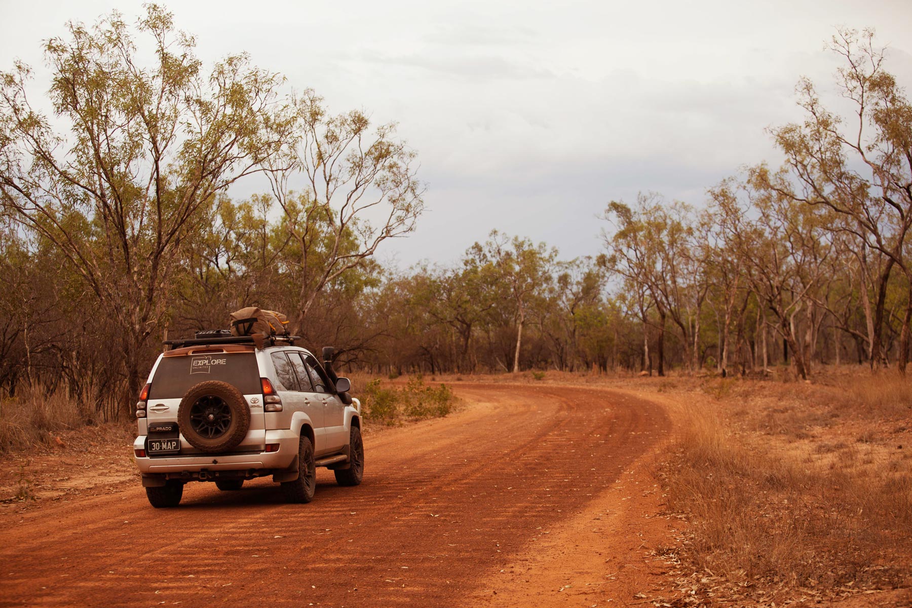
Limmen National Park is a remote and isolated park located in the Gulf Region of the Northern Territory. Access is limited to the Roper River Highway in the north and the Carpentaria Highway in the south, with the gravel Nathan River Road the only route between them through the park.
It’s perfect for travellers looking for a remote experience in an untamed landscape, but you’ll need to be fully self-sufficient with a well-maintained 4WD vehicle and offroad-capable trailer when you visit. There are no services, supplies or fuel in the park between Mataranka and Cape Crawford — a distance of 520km.
Visitors, other than NT residents, need to have an NT Parks Pass and fees apply. Check the park road conditions before travelling (P: 1800 246 199 / 08 8975 9940).
Nature and history abounds
Eucalypts dominate the sparse savanna woodlands of the park, which harbour hundreds of plant species and abundant wildlife. During the dry season, the network of shallow creeks shrinks to isolated billabongs and lagoons, ideal for birdwatching. Extensive coastal wetlands are critical habitats for migratory birds, while the sandy shores are important nesting grounds for flatback turtles. Limmen is also a favourite with anglers and four-wheel drivers.
Many groups of Indigenous people have connections with the park. Their ancestral lands are rich in art, artifacts and sacred sites that reveal occupation over tens of thousands of years before the arrival of Europeans. Stencilled rock art in a shelter known as Yilbilinji is considered very rare for being in miniature form, one of only three known examples of such art in the world.
In 1884, John Costello acquired the ‘Valley of the Springs’, a huge pastoral lease between the Roper and McArthur Rivers and stocked it with 15,000 head of cattle. However, Costello’s enterprise faced extreme difficulties — several stockmen were speared by Indigenous people and his herd was decimated by disease. He was forced to abandon the property in 1891.
Travelling along Nathan River Road from the north you come to Lomarieum Lagoon, near the ruins of St Vidgeon Homestead. During the dry season, this long, paperbark-fringed stretch of water is carpeted with water lilies and teeming with birdlife. It’s a great place to break the journey with some birdwatching or make a peaceful camp. During the wet season, the lagoon overflows and joins the Roper River, acquiring estuarine crocodiles in the process.
Nathan River Road has no fuel or services for over 340km
The Towns River is one of the major, and most picturesque, waterways traversing the Park. You can bush camp here in either a defined camping area set back from the river among light scrub, or on a broad sandstone platform running along the southern bank. The sunset over the opposite bank is spectacular. It’s an immensely popular spot for anglers and there’s a natural boat launching area at the riverside camp.
The Limmen Bight River is the largest in the park. Fed by 15 tributaries, including the Cox and Nathan Rivers, draining a catchment of nearly 16,000sq km, the river flows north across the plains in a series of braided channels. Its pristine estuary — a large tide-dominated delta with multiple channels surrounded by mangroves — will delight fishing enthusiasts.

The natural boat ramp on the Limmen Bight River
What to see
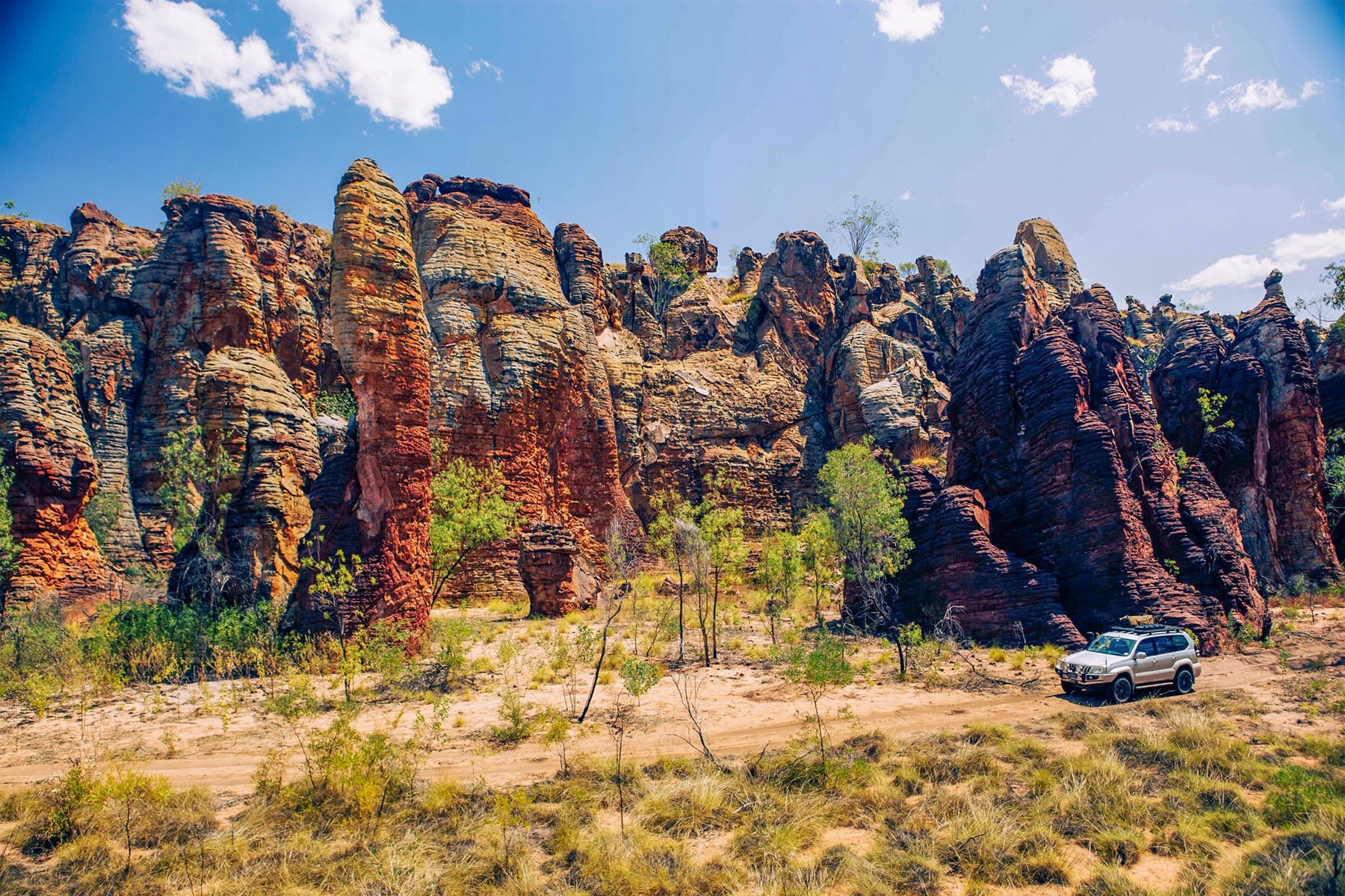
Limmen National Park’s main attractions are the magnificent sandstone formations grouped at two locations known as the ‘Southern Lost City’ and the ‘Western Lost City’. These spectacular structures rising from the rugged terrain are the product of geological forces that began 1500 million years ago, when sandy sediments accumulated on the bed of an ancient sea. Over millions of years these layers were compacted and cemented into sandstone. Tectonic forces raised the sandstone foundation out of the sea, bending and cracking it with a network of fissures. Exposed to the elements, wind and water slowly eroded the gaps, carving out the chasms and deep-red pillars we see today.
This towering rock guards the entrance to Western Lost City
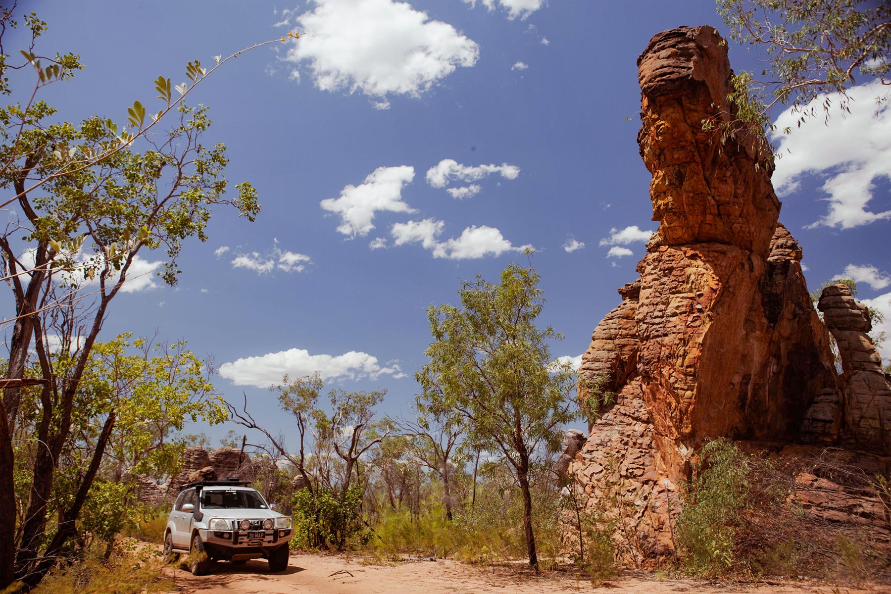
The Southern Lost City is 35km south of the Nathan River Ranger Station, accessed by a track from the main road that ends at a car park and camping area. From here, a short walk along a 2.5km walking trail explores the amazing landscape of quartzite ridges and colourful spires standing (or leaning) up to 25m high.
More difficult to access, the Western Lost City lies at the end of a 28km 4WD track that begins near the ranger station. You’ll need the access code (changed weekly) — which is provided on the whiteboard at the ranger station — to unlock the access gate. Trailers are not recommended on the rough track and should be left in the station parking area. For a special experience, view the ‘Cities’ on a scenic helicopter flight out of nearby Cape Crawford or Borroloola.

The sandstone formations of the Southern Lost City can be enjoyed via the circuit walk
Where to stay
There are a few accommodation options available on or near the river. About 25km along a track from the Nathan River Road, the Limmen Bight River Camp (P: 08 8975 9844) makes an ideal base for a fishing expedition, with cabins, powered campsites, basic facilities and limited fuel. Along the road to the fishing camp is a small Aboriginal outstation surrounding the pleasant Maria Lagoon, offering a low-key camping ground with basic facilities. Back on the Nathan River Road, the Park-operated Limmen Bight River Campground is located near the river crossing, with compost toilets, wood barbecues and picnic tables.
South of the Limmen Bight River crossing, the road passes the ranger station at Nathan River and comes to a popular waypoint and camp at Butterfly Falls. This beautiful oasis embraces a melaleuca-lined billabong at the base of a rocky outcrop cleft by a narrow cascade. It’s named for the masses of common crow butterflies that shelter from the sun in the cool shade of an overhang to one side of the billabong. A sandy beach provides easy access to the waterhole, one of the few places in the park where it is safe to swim. The camp has fireplaces, picnic tables and toilets.
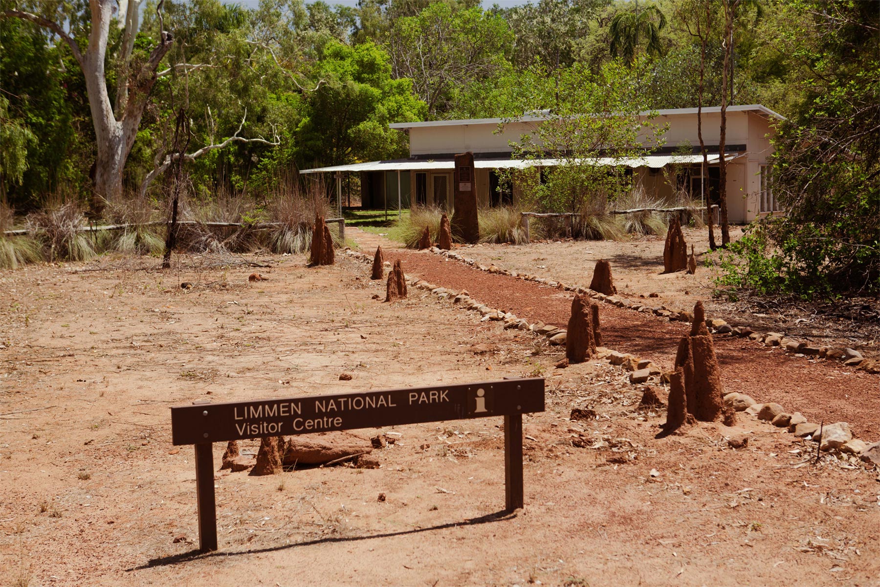
There are five camping areas within the park. As well as those already mentioned, the recently upgraded Munbililla (Tomato Island) Campground in the northern end of the park offers 55 unpowered sites suitable for caravans and tents in an open, grassy area, with water, gas and wood barbecues, hot showers and flushing toilets. There is a boat ramp with fish cleaning facilities nearby. Camping at all locations must be booked online before you visit, and fees apply. For more information contact the NT Parks and Wildlife regional office at Katherine (P: 08 8973 8888) or the Limmen ranger station (P: 08 8975 9940) or head here.

Burketown Crossing campsite
Hema Maps will release its new publication Top End and Gulf Atlas and Guide in September 2024 which will contain information and maps about Limmen Park and other Northern Territory attractions. Keep an eye out for it!
Next steps
At Hema Maps, we strive to provide the most comprehensive and accurate maps and guides for outdoor enthusiasts looking to explore Australia's natural wonders.
Did you find this information useful? If so, please share it with your fellow explorers. Whether it's by SMS, social media, or email, your friends and fellow adventurers will appreciate the valuable tips and insights we've shared.
Let's work together to make the most of every adventure.
2 comments


Hi Jeff, Jean and I in company with TLCC members enjoyed the south lost city when Nathan river station was still a cattle station shortly after the cattle brucellosis program and it was superb, those were the days, Col.
At Tomatoe Island camp as far from the rd to Roper bar as you can closer to the river (depending on wind, bad dust)
choppers use to leave from Loreta downs to the lost cities, and gulf fishing until closed down. Keep an eye out for the RED Bull.